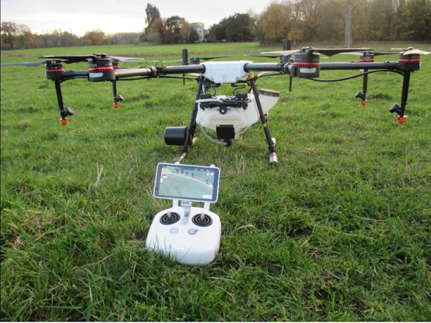
Drone technology in agriculture
They
increase crop efficiency, lower costs and are respectful with
the environment; drones have burst into the agricultural sector with multiple
possibilities from above, offering various solutions and benefits for so-called
precision agriculture.
And it is because
the use of this technological tool has allowed that it is no longer necessary
to use only satellite or aircraft images to obtain images of crops, a practice
that was often poorly detailed, expensive, sometimes imprecise and many times
discontinuous due to weather difficulties.
Today, it is possible to have fast,
detailed and high precision information thanks to drones; Let's see how the use
of these unmanned aerial vehicles in agriculture can make a difference.
The arrival of drones in the agricultural
sector
Some years ago, the difficulty of having
images of the crops in a timely manner forced farmers to use alternative
methods to obtain data. Thus, aerial photographs began to be taken with the
help of manned aircraft.
This activity, which initially offered very
good results, had some drawbacks for users: high costs per flight and
logistical problems, especially when several acquisitions were needed to
temporarily monitor the crops.
This is how the first proposals to use
unmanned aerial vehicles - UAVs in the work of collecting images that help to
properly manage crops emerged. The use of high definition cameras and video
recorders mounted on the drones allowed a much faster and more efficient work
in terms of costs.
Subsequently, the drones were provided with
GPS, which helped direct them through a programmed autonomous tour, over the
area from which the information was to be extracted. In this way, data could be
collected with greater precision, autonomy and security.
Thus, at present, drones equipped with GPS
start from a base, carry out a previously established flight through
specialized software and return at the scheduled time with very valuable data
for farmers. After the corresponding battery charge, they are ready for the
next flight.
This technology allows you to automatically
program the day and time of the next flights, as well as collate the
meteorological data to carry out the flight according to the meteorological and
lighting conditions.
Types of drones for agriculture
There is a wide
variety of drones that are used as tools for precision agriculture. Among them,
the multirotors or rotary wing stand out, which are the most used and come
equipped with a motor at each end of the chassis.
There are also
those with fixed wings, which are similar to the classic airplanes and that
have a wing profile that gives them the possibility of supporting themselves
and moving through the air, which gives them great flight autonomy.
For their part,
VTOL aircraft have the ability to take off and land vertically, while
helicopters are so named because of their resemblance to life-size ones.
Depending on the
specific use that will be given to this vehicle, the most suitable drone for
the task can be chosen. For example, fixed-wing drones are ideal for mapping
large areas, thanks to their great autonomy that allows them to cover large
areas in a single flight.
If what is needed
is to collect data from medium-sized surfaces, it is convenient to use a
rotary-wing drone, since they are more versatile due to the fact that they take
off and land vertically.
Drones that are equipped with
multispectral cameras are very useful for taking images in crops, especially
those that are sensitive in the near infrared region. When flying at such a low
altitude (<120 m), the vegetative state of can be visualized with a sampling
detail of less than 10 cm, or in other words, at the leaf level ... being a
good alternative to satellite images.
Uses of drones in agricultural tasks
The drone revolution in agricultural work allows its low flight height to
be exploited to carry out activities that previously farmers could only do from
the ground. A drone with multispectral cameras can, for example, analyze solar
energy reflected by vegetation in a region of the electromagnetic spectrum
(near infrared) that is directly correlated with the health of plants.
Generally, they
are autonomous flights with multispectral or thermal sensors with which data is
captured, aerial maps are generated, and relevant information is generated for
decision-making. The key is in the information, statistically analyzed to
generate state patterns, vegetation indices, detect pathologies and alert about
anomalies.
With this
technology, it is possible to determine if there are areas of the land that are
more humid or drier, analyze if a certain crop is green or mature or establish
the amount of chlorophyll or nitrates. Through thermographic images, water
stress or chlorosis problems can be observed.
Some of these
drones are used to simulate birds of prey and with their flight scare away
large flocks of birds that are harmful to crops. Also, drones are being used
for phytosanitary treatments in the vineyards, based on the maps that have been
generated from the drone itself and that identify critical points where it is
necessary to apply products.
Fixed-wing UAVs
can scan more than 200 hectares of land area in a single flight. In the case of
flying over a swamp, one of its immediate applications is the detection of
possible pollutants from its multispectral sensors.
Increasing
production, improving crop quality and optimizing costs are just some of the
benefits that these unmanned aerial vehicles offer us; For this reason, more
and more farmers are turning to new technologies to get the most out of their
crops.
From this new
aeronautical sector, the expectations generated with the use of drones for the
field bring us closer to a much more efficient and productive agriculture.


0 Comments
don't spam comments, please ...